Questions Fly at Roosevelt Boulevard Town Hall
Project managers for PennDOT's planned makeover of the thoroughfare fielded pointed questions from attendees.
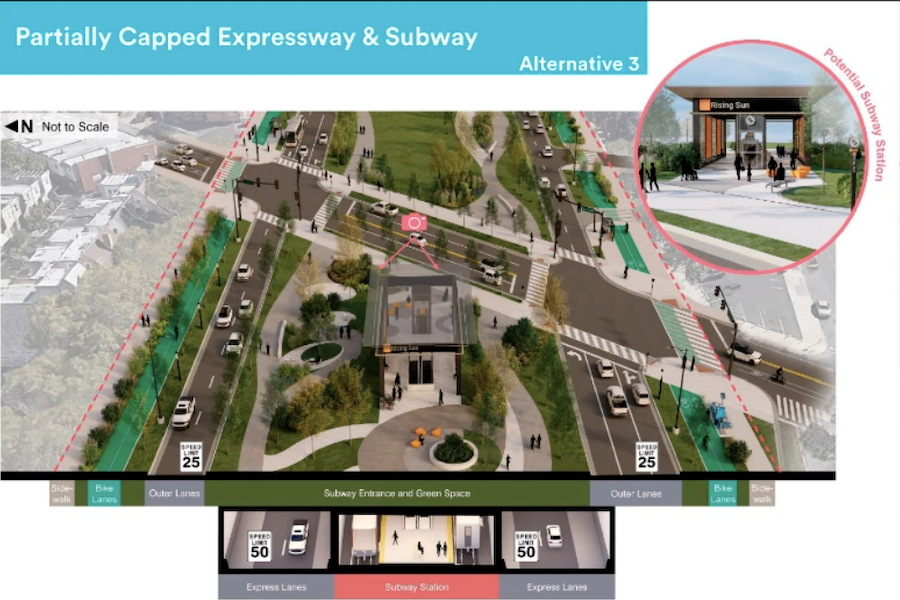
This design, which would place a subway between the lanes of a partially covered freeway, was one of six presented at a virtual town hall on the Roosevelt Boulevard Route for Change project on January 29th. / Renderings by HNTB for the City of Philadelphia, the Pennsylvania Department of Transportation and SEPtA
For those who couldn’t make the three in-person information sessions in December, the City of Philadelphia, PennDOT and SEPTA held a virtual town hall meeting this past Wednesday night to introduce participants to the six options being considered for the “Route for Change” remake of Roosevelt Boulevard.
The reason for the remake: to make the city’s second-most-dangerous thoroughfare safer for all who use it — drivers, pedestrians, transit users and neighbors alike.
“Every month, one person dies and three others suffer serious injuries” as a result of accidents on the Boulevard, explains Fernamdo Mascioli, project manager for HNTB. “And one in every four of those deaths is a pedestrian or bicyclist.”
The 14.9-mile-long road’s wide footprint — wider than a football field in some places, according to Mascioli — contributes to its danger because of the difficulties it poses to pedestrians trying to cross it and bicyclists trying to use it. And it was with these two groups uppermost in mind that the study produced its six recommendations.
The six options are based on two roadway configurations — a four- to six-lane surface boulevard with a partially capped four-lane freeway in its middle or an eight-lane surface “neighborhood boulevard” consisting of two roadways in each direction, each with two lanes plus left-turn lanes in the inner pair.
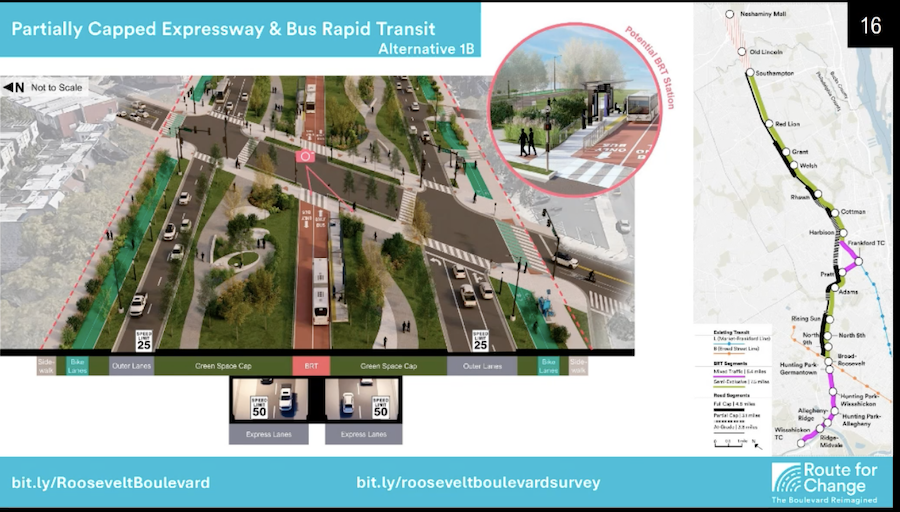
This slide shows Alternative 1B — a bus rapid transit facility located over the freeway. The map on the right shows the BRT line in pink.
On top of these are three options for mass transit. One is a bus rapid transit facility, the second is a light rail line, and the third is a subway. All three would begin somewhere north of Southampton Road, most likely at Neshaminy Mall; the BRT and LRT routes would divert to serve Frankford Transportation Center, then continue down Hunting Park Avenue to Wissahickon Transportation Center beyond the Boulevard’s end. The mostly cut-and-cover subway would follow the Boulevard to 9th Street, then cross under Hunting Park in a bored tunnel to reach an existing connection with the Broad Street Line north of Erie station.
All six options include dedicated bike lanes.
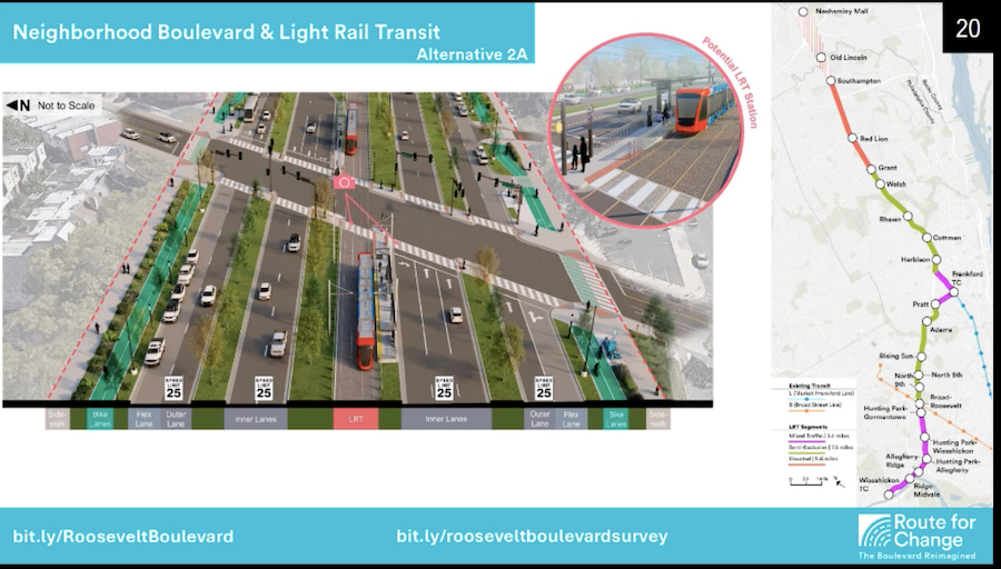
Alternative 2a, shown here, has a light rail line running in the median of an eight-lane neighborhood boulevard. Again, the LRT line appears in pink.
As at the in-person town halls, the project’s leaders walked participants through the fairly lengthy timetable for rebuilding the Boulevard. They then explained each of the six options for rebuilding the Boulevard presented in the report HNTB produced in December and explained the main pluses and minuses of each option.
Participants also saw a table of cost and ridership projections. Estimated project costs ranged from $1.9 billion for bus rapid transit in a neighborhood boulevard to $15.8 billion for a subway between the lanes of a partially capped expressway. (As studied, the subway would rise to an elevated structure north of Grant Avenue.) Ridership projections ranged from between 30,000 and 40,000 daily riders on average for the BRT in a neighborhood boulevard to more than 60,000 average daily riders for the two subway options.
The presenters also encouraged attendees to complete the survey on the 2040 Alternatives to Transform the Boulevard website if they had not done so already.
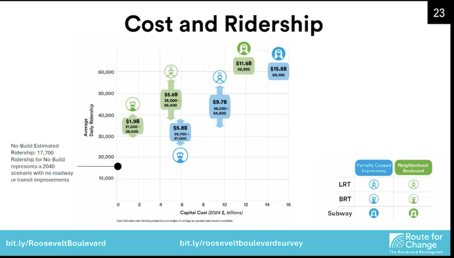
This chart shows the estimated costs and average daily ridership projections for each of the six alternatives.
In addition to Mascioli, PennDOT Project Manager Alexa Harper, City of Philadelphia Roosevelt Boulevard Program Coordinator Matt Wysong, city Manager of Planning Programs Matt Zapson and HNTB Transportation Planner Chris Jandoli spoke during the presentation.
After the presentation, the hosts opened the floor for audience questions. The questions largely fell into three broad categories. One group of questions stressed the need to prioritize the views of Northeast residents as the sponsors whittled the alternatives down from six to three, then from three to one. One questioner specifically asked that the project leaders take into account the expressed desires and concerns of Northeast residents rather than “those who just like trains.”
One participant pushed back against this view somewhat, however. They pointed out that improved transit would enable people in other city neighborhoods to visit the Northeast more easily and Northeast residents to get to more of the city quicker.
Another group of questions concerned the physical appearance of the Boulevard itself. As the presenters also showed two different forms of urban design, both of which can be found on the Boulevard today — the corner store model, where commercial businesses front on sidewalks, and the shopping-center one, where parking lots separate businesses from the street — some questioners expressed concern that the shopping centers might go away.
And a third set of questions dealt with the roadway options. At least one person attending the meeting wondered why the neighborhood boulevard had to have so many lanes, while a few others wondered whether the roadway would have enough capacity to handle the cars that would still use it. (The presenters explained that one goal of the project is to reduce the number of cars and vehicle-miles traveled on the Boulevard.)
Some in attendance asked about travel times for each of the three options. Although the presenters declined to provide those estimates, the report released in December contains them.
According to the report, both the BRT and LRT options would take 33 minutes to travel from Neshaminy Mall to Frankford Transportation Center, 45 minutes to reach Hunting Park station on the Broad Street Line and an hour and five minutes to reach Wissahickon Transportation Center. The subway would take 26 minutes to get from Neshaminy Mall to a new interchange with the Market-Frankford Line at Bustleton Avenue, 40 minutes to get to Erie station, and 49 minutes to reach City Hall via the Broad Street express tracks.
BRT and LRT riders would transfer at either Frankford Transportation Center or Hunting Park station to reach Center City while subway riders could use the Market-Frankford Line to reach other points in Northeast Philadelphia, Kensington, Fishtown, Northern Liberties and eastern Center City.
The current study is actually the second one conducted under the auspices of Route for Change. The first, conducted from 2015 to 2021, did not include a subway as one of the transit options for the Boulevard. PennDOT then agreed to conduct this second study after subway advocates pointed out its absence. This study took as its starting point for considering subway options a 2003 study the city had conducted that recommended building the Roosevelt Boulevard line, which first appeared on city transit plans in 1913.
One more public outreach event remains in this first phase: a virtual “Transit Talk” on Monday, February 3rd. After that, the Route for Change team will whittle the six alternatives down to three based on public feedback. The three finalists will then undergo another round of public feedback from the winter of 2025 through early 2026. After that, PennDOT will announce the alternative to be built starting in 2040.
In between now and then, however, PennDOT is undertaking some incremental improvements to the Boulevard. You can learn about these, some of which have been completed already, on the Roosevelt Boulevard Route for Change website.