This Is the Best Worst Map of Philadelphia Ever
When did City Hall move to Northeast Philly, and why are those giant eggs attacking Roxborough? We have so many questions.
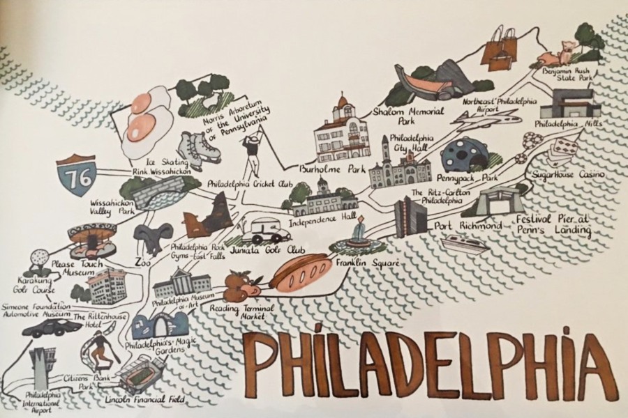
The worst (or best?) map of Philadelphia. | Photo courtesy of Dan McQuade
In the competition of the worst maps of anywhere ever, we’ve got ourselves a winner, Philly!
The map pictured above presents a never-before-seen and completely unrealistic depiction of our city. I’ve been sitting here wrestling with this beast, and I truly can’t tell if I need to pick one up and hang it in my living room right now — or if I need to collect every version everywhere and throw them all in a giant, flaming dumpster.
I was first alerted to the existence of this creation by former Philly Mag reporter Dan McQuade. McQuade said his fiancé’s mom recently bought it from the HomeGoods in Montgomeryville, Pennsylvania, as a gift. It’s from art collective Marmont Hill — which markets “awesomely designed artwork,” including plenty of other maps just like it (for Boston, New York, Florida, and more).
McQuade posted a photo of the map to Twitter, which, of course, prompted a quick and fierce outcry from skeptic Philadelphians. They, like all of us, had so many questions.
as we all know, the Schuylkill River flows directly into a pair of fried eggs in Conshohocken
— Stephen Pianovich (@SPianovich) May 14, 2019
First things first, why is Roxborough (or Overbrook … you just don’t know with this map) being attacked by pair of giant eggs? I mean, most landmarks included on this map are attached to words that provide some sort of explanation (aside from the hotdog slide that links Franklin Square to Reading Terminal Market, of course), but we’re left to grapple with the eggs on their own. They’re mysterious. Are they a sort of gate to the Schuylkill River? Is there a really good diner in Roxborough (or Overbrook) that we’re unaware of? Will we ever know?
Second, why is City Hall in Northeast Philly, above the Juniata Golf Club? Why is the Juniata Golf Club on the map at all? And while we’re in the Northeast, what’s with the brown paper shopping bags? What do they stand for?
And speaking of shopping, it’s worth noting that the map identifies Franklin Mills Mall by its newer, “official” name, Philadelphia Mills, which every Philadelphian will tell you just doesn’t feel right.
That’s why Philly’s so convenient— you can fly in, visit City Hall, go to the rock gym, and ZOO all on one road.
— Mo Manklang (@MoManklang) May 15, 2019
Moving south, let’s consider the cartographer’s choice to include the Ritz-Carlton in/near Port Richmond (a neighborhood which could’ve been represented by a pierogi). It’s a Ritz-Carlton. Then heading west, we find the Philadelphia Rock Gym at East Falls. It’s a great gym and all — I occasionally visit myself — but it’s not exactly Philadelphia landmark material.
Two more points, and then we’ll leave this map to you for your own deciphering. Please note that the Philadelphia Zoo is simply called “Zoo.” And thanks to this experience, I’ve now learned that the Karakung Golf Course and the Simeone Foundation Automotive Museum exist.
Now, I know you’re dying to get your hands on one of these maps, but an employee for the HomeGoods in Montgomeryville said the store doesn’t currently have any in stock (we called) — and sadly, Marmont Hill doesn’t list this gem on its website. (McQuade got lucky, apparently.)
The good news? You can draw your own map of Philadelphia pretty easily, and there’s a decent chance it’ll be more realistic than this one. Even SEPTA’s are better.