More Snow Is on the Way for the Philadelphia Area

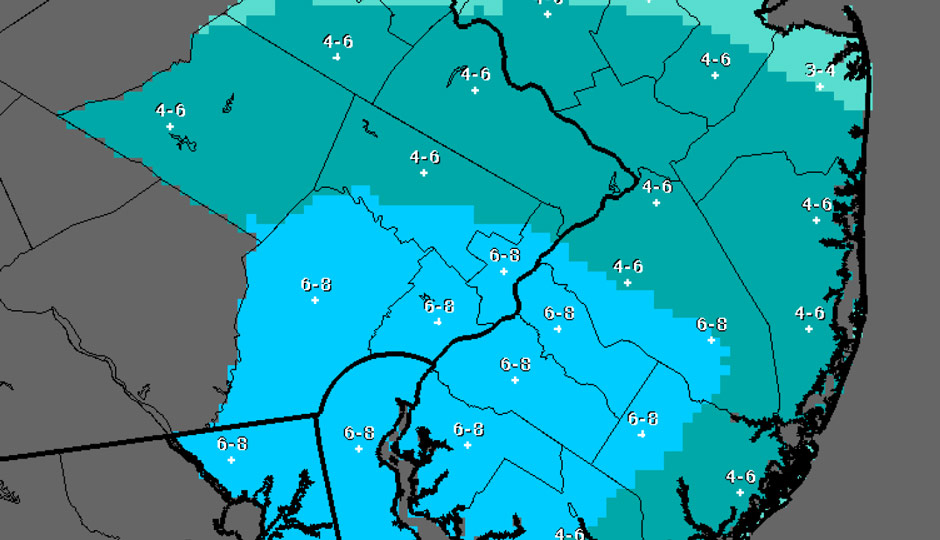
Forecast via National Weather Service
We’re getting more snow.
Though the city was mostly spared from last week’s storm, another winter weather system is headed our way late tonight into tomorrow. The National Weather Service says the most likely snowfall result in Philadelphia is 4-8 inches of snow from tonight until tomorrow night.
“This may not be on the scale of last month’s blizzard, but we are treating this as a full-scale event,” Clarena Tolson, Deputy Managing Director for Infrastructure and Transportation, said in a release from the City of Philadelphia. “We want to make sure we’re out there ahead of the storm.” Tomorrow’s trash and recycling collection is canceled. The city says it does not expect to declare a snow emergency.
Salting and plowing will begin tonight and continue through tomorrow.
As Glenn “Hurricane” Schwartz of NBC 10 notes, this is the kind of storm that’s tough to predict. The NWS says the best case scenario is that we get less than an inch of snow from tonight into tomorrow.
Schwartz says we’ll get about 1 to 3 inches. A different Glenn — Glenn Schreiber, of “The Weather Guy” blog — said 4 to 6 inches this morning, but says it’s a “low confidence” forecast — and that the sunshine this afternoon was unexpected. (Schreiber was right on his forecast for the late January storm.)
Read the NWS forecast discussion and you get a sense of the uncertainty surrounding this storm: A winter storm watch begins tonight and lasts for 28 hours, because some models say it’ll start late tonight while others say late Tuesday afternoon into the night. “Very few scenarios can be ruled out at this point,” the NWS writes.
Meanwhile, an offshore storm today has led to massive flooding at the shore.
Trash can bobs along on flood tide in #OC. #acpress pic.twitter.com/q57EKyVKwn
— Cindy Nevitt (@ACPress_Nevitt) February 8, 2016
There are also coastal flood warnings in both New Jersey and Delaware for the next two high tides.
Follow @dhm on Twitter.


