UPDATE: Hurricane Joaquin Upgraded to Category 4

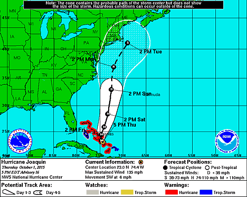
National Weather Service prediction for Hurricane Joaquin as of October 1st at 5 p.m.
[UPDATE 7:55 P.M.] The National Weather Service has moved Hurricane Joaquin’s “cone of uncertainty” east, dropping the chance of a costly, destructive storm. Most of the region’s outdoor events remain on. [The NWS’s most recent briefing package is here.]
[UPDATE 2:42 p.m.] The National Weather Service has upgraded Hurricane Joaquin to Category 4 storm, “extremely dangerous” as it passes through the Bahamas.
“We don’t know what this hurricane is going to do, what impact it’s going to have on Pennsylvania, but we’re doing everything we can do” to be prepared, Pennsylvania Gov. Tom Wolf said at an afternoon news briefing. He urged residents to have three days of food and medication, and to stay in their residences unless evacuated. [The NWS’s most recent briefing package.]
"We don't know the impact on PA, but we are making sure we are ready." -Gov Wolf on Hurricane Joaquin pic.twitter.com/TEZ8zP0Ow3
— Eric Heisler (@Heisler_Eric) October 1, 2015
[Original 12:04 p.m.] Hurricane Joaquin is currently hitting the Bahamas hard, with max sustained winds of 120 miles per hour. But is it going to hit the mainland U.S.? And will it effect Philadelphia?
Whatever happens, the area is buckling down: N.J. Gov. Chris Christie today declared a state of emergency, readying itself for the first major storm since Superstorm Sandy hit coast three years.
The forecast for Hurricane Joaquin is still quite unclear, however. The cone of uncertainty — which you can see on the image above — is the possible paths meteorologists think the hurricane could take. The National Hurricane Center says it’s still too early to figure out what the hit could be: “It’s too early to talk about specific wind, rain, or surge impacts from Joaquin in the United States. Regardless of Joaquin’s track, strong onshore winds will create minor to moderate coastal flooding along the coasts of the mid-Atlantic and northeastern states through the weekend.”
The storm is expected to be strong, with max sustained winds of 140 miles per hour. Accuweather says the storm will become a Category 4 hurricane later today. As you can see, by the time it makes a possible landfall, though, it will probably be a Tropical Storm with much slower winds.
Phillywx says says the model is starting to shift, and Joaquin may not hit the U.S. mainland at all: “Forecast still uncertain BUT odds are leaning as of this morning towards a close call/miss with landfall. That does not mean there won’t be issues at the Shore or Delaware Beaches into the weekend. It won’t be a walk in the park there for a few days.”
Whatever happens, it looks like we’re going to have a wet weekend. The National Weather Service Mt. Holly/Philadelphia says we’re in for high winds and sustained rain over the next few days. Which could mean an interesting weekend: Both the Midtown Village Festival and Bloktoberfest are on Saturday and the Phillies are at home. Then on Sunday, the Pulaski and Puerto Rican Day parades are scheduled to take place.