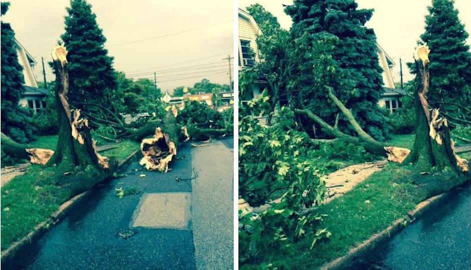
Storm Effects Disrupt Morning Rush

Pictures by Victor Fiorillo.
Good morning. Your commute may be interfered with by service disruptions caused by last night’s severe storms. Here is what we know:
• PATCO service remains suspended. “PATCO remains without power from Tuesday evening’s storm and PSE&G has advised electricity will not be restored until at least after mid-morning on Wednesday, 6/24. Crews are working hard to restore service as quickly and safely as possible.”
• So are some SEPTA regional rail lines: Paoli/Thorndale is suspended between Thorndale and Malvern, though service remains between Malvern and Center City. Service remains suspended on the Fox Chase and Media/Elwyn lines. The Norristown High Speed Line has service to Radnor Station only. For updates on all routes, check SEPTA’s system status.
• PECO is reporting widespread outages, still: At least 50,000 customers in both Chester and Delaware counties, as well as at least 1,000 customers each in Montgomery, Philadelphia, and York counties.
• Similarly, PSE&G estimates more than 45,000 customers are without power in South Jersey.
The severe weather threat has passed. The severe thunderstorm watch for our county warning area is no longer in effect….
Posted by US National Weather Service Philadelphia/Mount Holly on Tuesday, June 23, 2015
Severe thunderstorms tore through the Delaware Valley this evening with damaging winds, blinding downpours and relentless lightning. Wind gusts exceeding 70 mph knocked downed thousands of trees, poles and wires, causing power outages for hundreds of thousands of customers from the Poconos to Jersey shore the Delaware beaches.
The hardest hit areas were the suburbs of Philadelphia. Highways and roads became impassible. Some due to toppled traffic lights and others because of debris and accidents. Many people just pulled over or stopped because the visibility was so poor they couldn’t see ten feet in front of them during the torrential rains. Numerous homes and cars were crushed by downed trees and trains and planes were cancelled or delayed during the height of the storm. Over 5,200 cloud to ground lightning strikes were counted between 5PM-9PM and that’s nearly a lightning strike every 2.7 seconds.
Two days into summer 2015, a severe thunderstorm accompanied by lightning rumbled through Delaware County — flooding streets, downing electrical wires and toppling trees. Images of widespread damages were all over social media.
“Looks like a disaster area,” one woman who drove from her home in Swarthmore to work in Middletown posted on Facebook Tuesday night. “No traffic lights all the way from home to Lima. Trees and wires down. Emergency vehicles everywhere.”
Another woman, who lives in Aston, posted on Facebook page, “Wish I knew where my gazebo got to.”
A car was flipped and pieces of the Deptford Mall’s exterior were ripped off as a violent storm, described by witnesses as a tornado, sprinted across South Jersey Tuesday night.
The National Weather Service will decide Wednesday whether to travel to Deptford to investigate whether a tornado caused the damage. Winds were clocked at more than 70 mph at the height of the storm.
AP reports the storm battered much of the East Coast, and even parts of the Midwest:
The National Weather Service issued a tornado watch for much of southern New England, and strong thunderstorms in Connecticut caused widespread power outages. Storms moving into Philadelphia on Tuesday evening blackened the sky and temporarily halted commuter trains beginning at rush hour. Amtrak suspended its Northeast Corridor and Keystone services from Washington through Philadelphia and on to Harrisburg, Pennsylvania, but restored service about two hours later.
Strong storms that swept across northern Illinois spawned at least nine tornadoes, severely damaged homes and forced first responders to pull survivors from basements, officials said Tuesday.
More to come.


